Profiles (Settings)
This article is incomplete & needs to be reviewed. You can help by creating a pull request.
Overview
The following profiles are available by default: Browse map, Driving, Cycling, Walking, Truck, Motorcycle, Moped, Train, Public transport, Boat, Aircraft, Skiing, Horseback riding. Each profile is available for full configuration. Of course, you can create your own profile with full customization.
Truck, Motorcycle, Moped, Train, Aircraft, Boat and Horseback riding profiles are switched off by default. In order to use these profiles, you need to activate them in Menu → Settings → App profiles.
- Android
- iOS
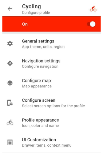
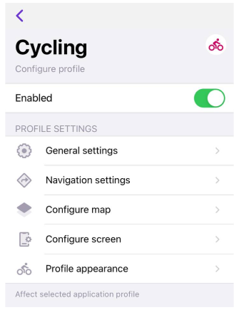
Menu → Configure profile (Browse map or any other profile)
Menu → Settings → App profiles
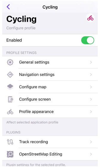
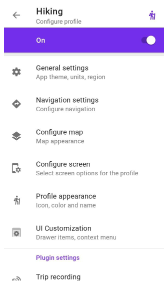
Profile configuration
This section contains all the settings related to the appearance, navigation settings, map rendering, configure menu, and screen of a profile.
All settings affect the selected application profile only.
- Android
- iOS
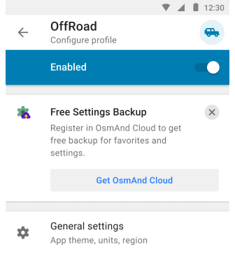
Free Cloud backup
- Android
- iOS
Menu → Configure profile
Menu → Settings → App profiles
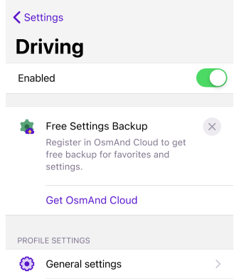
OsmAnd provides the ability to backup your application profile settings and save them in OsmAnd Cloud. Thus, your settings will be safely and conveniently saved for Android, iOS, or Web versions and restored in case of device failure or reinstallation of OsmAnd app. You can use this special plan if you have OsmAnd Free or Maps+.
You need to have an OsmAnd Cloud account to use the Free Settings Backup. If you have an account in OsmAnd Pro or an active account in OsmAnd Cloud, you will not see the promotion banner.
- Tap the Free Settings Backup banner.
- Go through the registration step.
- Then go to the OsmAnd Purchases menu (Menu → Settings → Purchases).
- Select the OsmAnd Start package.
- Create a backup.
General settings
This section contains settings of the cursor on the map and map view, settings of units & formats of map and profile data, settings of external input devices, and other sensors.
Appearance
- Android
- iOS
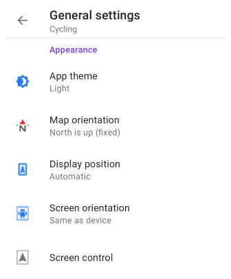
Menu → Configure profile → General settings → Appearance
Menu → Settings → App profiles → General settings → Appearance
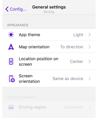
In this section of the General settings menu, you can set parameters for the cursor on the map and map view for the chosen profile.
App theme. Allows you to set a day and night theme for the app, which can be applied to one profile or to all at once. This option does not change the map mode settings.
- Dark theme
- Light theme
- System default. Applies the system theme. By default and for all new users, the map style corresponds to the light or dark theme selected in your device's system settings.
Map orientation. Allows you to choose the map orientation mode for the selected profile.
- North is up
- Movement direction
- Compass direction
- Manually rotated
Display position (Android only) / Location position on screen (iOS). Allows you to set the placement of the cursor My location on the Osmand map. There are three options available:
- Center. The cursor is always positioned in the center of the screen.
- Bottom. My location is placed slightly below the center of the screen. This mode allows you to see more map information ahead of your movement, which is very useful during navigation.
- Automatic. Places My location depending on Map orientation (Bottom for movement direction, Center - for all others).
Screen control (Android). Opens the screen control menu, where you can select options for the device screen while navigating to save device battery consumption.
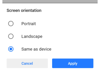
Screen orientation. Sets and locks the screen position in the OsmAnd application. Not supported on iPad.
- Portrait
- Landscape
- Same as device
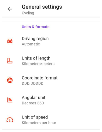
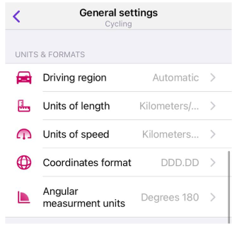
Units & formats
In this section you can set parameters of units & formats for chosen application profile.
- Android
- iOS
| Parameter | Format | Note |
|---|---|---|
| Driving region | Automatic | According to the device location |
| Europe, Asia, Latin America, and similar | Right-hand traffic, Kilometers/meters | |
| United States | Right-hand traffic, Miles/feet | |
| Canada | Right-hand traffic, Kilometers/meters | |
| UK, India, and similar | Left-hand traffic, Miles/feet | |
| Japan | Left-hand traffic, Kilometers/meters | |
| Australia | Left-hand traffic, Kilometers/meters | |
| Units of length | Kilometers/meters | 1 km / 1000 m |
| Miles/feet | 0.62 ml / 3281 ft (1000 m) | |
| Miles/meters | 0.62 ml / 1000 m | |
| Miles/yards | 1094 ya / 0.62 ml (1000 m) | |
| Nautical miles/feet, Nautical miles/meters | 0.54 nmi / 3280.84 ft / 1000 m | |
| Coordinate format | DD°MM.MMMM′ | Example: 50.12333° 19.93233° (Lat Long) |
| DD°MM.MMM′ | Example: 50°7.393′ 19°55.941′ (Lat Long) | |
| DD°MM′SS″ | Example: 50°7′23.6″ 19°55′56.4″ (Lat Long) 23°27′30″ | |
| UTM Standard | 34N 5552876 423678 (Zone Northing Easting) . OsmAnd uses the UTM Standard, which is similar but not identical to the UTM NATO format. | |
| MGRS | Example: 34U DA 23678 52873 . OsmAnd uses MGRS, which is similar to the UTM NATO format. | |
| Open Location Code | Example: 9F2X4WFJ+7W (Open Location Code represents area 9m x 14m) | |
| Swiss Grid (CH1903) | Example: 2 215 227.87, 830 915.9 (Swiss coordinate system) | |
| Swiss Grid (CH1903+) | Example: 4 215 227.87, 1 830 915.9 (Swiss coordinate system) | |
| Angular unit | Degrees 180° | All angular values have readings from 0° to 180° and from 0° to -180°. |
| Degrees 360° | All angular values have readings from 0° to 360°. | |
| Milliradians | All angular values have milliradian value. | |
| Unit of speed | Kilometers per hour | 90 km/h |
| Miles per hour | 55.92 mph | |
| Meters per second | 30 m/s | |
| Minutes per mile | 1.073 min/m | |
| Minutes per kilometer | 0.667 min/km | |
| Nautical miles per hour (knots) | 48.59 kn |
| Parameter | Format | Note |
|---|---|---|
| Driving region | Automatic | According to the device location |
| Europe, Asia, Latin America, and similar | Right-hand traffic, Kilometers/meters | |
| United States | Right-hand traffic, Miles/feet | |
| Canada | Right-hand traffic, Kilometers/meters | |
| UK, India, and similar | Left-hand traffic, Miles/feet | |
| Japan | Left-hand traffic, Kilometers/meters | |
| Australia | Left-hand traffic, Kilometers/meters | |
| Units of length | Kilometers/meters | 1 km / 1000 m |
| Miles/feet | 0.62 ml / 3281 f | |
| Miles/meters | 0.62 ml / 1000 m | |
| Miles/yards | 0.62 ml / 1094 ya | |
| Nautical miles | 0.54 nml | |
| Coordinate format | DDD.DDDDD | Example: 50.12333° 19.93233° (Lat Long) |
| DDD MM.MMM | Example: 50°7.393′ 19°55.941′ (Lat Long) | |
| DDD MM SS.S | Example: 50°7′23.6″ 19°55′56.4″ (Lat Long) 23°27′30″ | |
| UTM | 34N 5552876 423678 (Zone Northing Easting) . Please note, OsmAnd uses UTM Standard format which is similar but not identical to UTM NATO. | |
| Open Location Code (OLC) | Example: 9F2X4WFJ+7W (Open Location Code represents area 9m x 14m) | |
| Angular measurement units | Degrees 180° | All angular values have readings from 0° to 180° and from 0° to -180°. |
| Degrees 360° | All angular values have readings from 0° to 360°. | |
| Milliradians | All angular values have milliradian value. | |
| Unit of speed | Kilometers per hour | 90 km/h |
| Miles per hour | 55.92 mph | |
| Meters per second | 30 m/s | |
| Minutes per mile | 1.073 min/m | |
| Minutes per kilometer | 0.667 min/km | |
| Nautical miles per hour (knots) | 48.59 kn |
Other
Additional settings for profile.You can switch buttons and input devices for OsmAnd, enable or disable animation for navigation mode, use or not the fullscreen mode, magnetic sensor, and Kalman filter. Not everything is available for iOS.
- Android
- iOS
Menu → Configure profile → General settings → Other
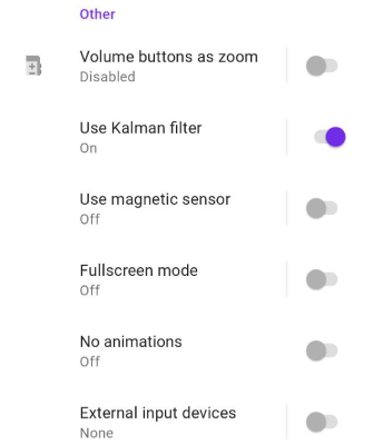
- Volume buttons as zoom - allows to use or not volume buttons of a device as zoom.
- Use Kalman filter - allows to use or not Kalman filter for smoothen rotation of the map with a slower rotation animation though it introduces a small delay (< 1 second) till.
- Use magnetic sensor - allows to use or not Magnetic sensor for smoothen rotation of the map with a slower rotation animation though it introduces a small delay (< 1 second) till.
- Fullscreen mode - tapping an empty space on the map hides control buttons and widgets.
- No animations - allows to switch on/off animation for navigation mode.
- Animate own position - Smooth map panning when in motion. Introduces slight delay. Note that the animation takes about 1 second, which creates a slight delay for the My location position to display on the map relative to your location.
- External input devices - allow you to add other devices, such as WunderLINQ, Keyboard, or Parrot, to control the OsmAnd program using the existing buttons.
Menu → Settings → App profiles → General settings → Others
- External input devices - allow you to add other devices, such as WunderLINQ or Keyboard, to control the OsmAnd program using the existing buttons.
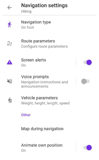
Navigation settings
- Android
- iOS
Menu → Configure profile → Navigation settings
Menu → Settings → App profiles → Navigation settings
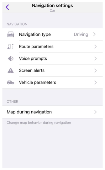
In the Navigation section, you can read all about the navigation settings in the OsmAnd app that you can use on your trips.
- Routing Types
- Route parameters
- Screen alerts
- Voice prompts
- Vehicle parameters
- Customise route line
- Map during navigation
- Animate location change
There are no navigation settings in Browse map profile.
Animate location change
This setting provides a smooth animation of the "My location" point moving on the map during navigation. Note that the animation takes about 1 second, which creates a slight delay for the "My location" position to display on the map relative to your location. For Android, this item named Animate own position is located in the "Other" section of the General Settings menu.
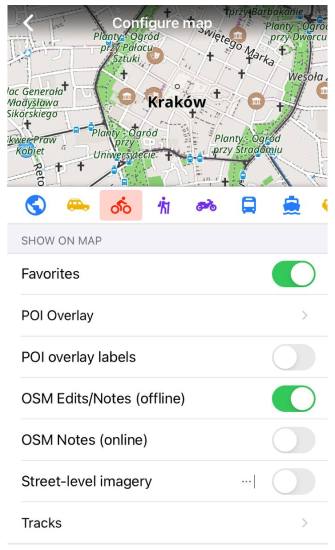
Configure map
Here you can set parameters for Configure map of chosen profile
Configure map menu is a central place where you could configure map display for your profile needs, i.e. highlight Favorite points, Navigation markers or special Points of Interests on the map; display specific routes or 3rd party GPX files; overlay the map with relief information, satellite imagery or any other available raster map; display public transport information and change the map style.
- Android
- iOS
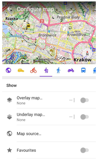
Menu → Settings → App profiles → Configure map
Set parameters for Configure map menu for chosen profile.
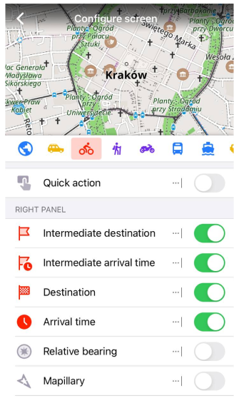
Configure screen
Here you can set parameters for Configure screen of chosen profile.
Configure screen is a menu that allows to configure what widgets will be displayed over the map. It allows you to enable and configure Quick action, Informational & Navigational widgets and other elements.
- Android
- iOS
Set parameters for Configure screen menu for chosen profile.
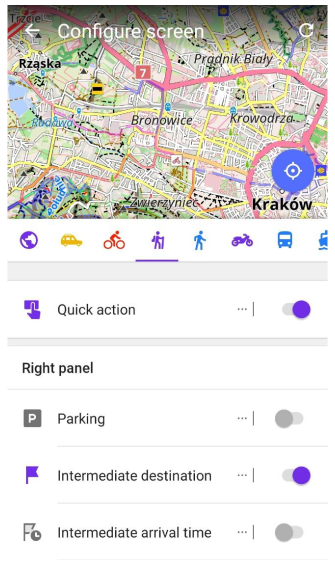
Set parameters for Configure screen menu for chosen profile.
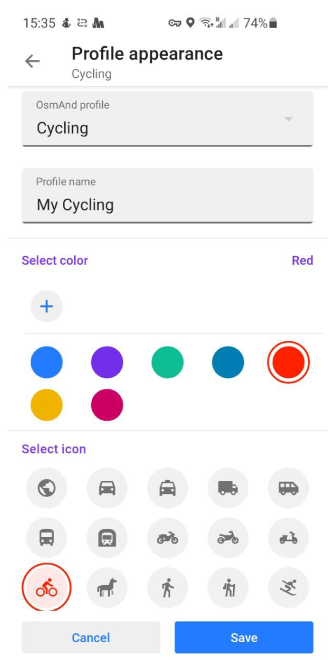
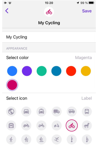
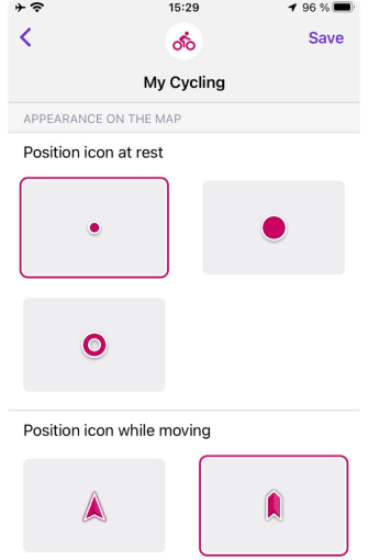
Profile appearance
You can choose the color of the profile elements, its icon and name, also assign icons on the map for movement and without.
- Android
- iOS
| Parameter | Description | Note |
|---|---|---|
| "Profile name" | entering a profile name | |
| "Profile appearance" | changing color and label for chosen profile: | |
| "Select color" | choosing color for a profile icon and menu | |
| "Select icon" | choosing label for a profile icon | |
 | ||
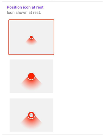
| "Appearance on the map" | changing position icons: | |
| "Position icon at rest" | choosing label for a profile icon without moving | |
 | ||
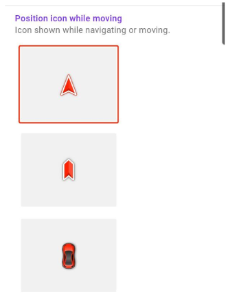
| "Position icon while moving" | choosing label for a profile icon while moving | |
 |
| Parameter | Description | Note |
|---|---|---|
| "[object Object]" | entering a profile name | |
| "Appearance" | changing color and label for chosen profile: | |
| "Select color" | choosing color for a profile icon and menu | |
| "[object Object]" | choosing label for a profile icon | |
 | ||
| "[object Object]" | changing position icons: | |
| "[object Object]" | choosing label for a profile icon without moving | |
| "[object Object]" | choosing label for a profile icon while moving | |
 |
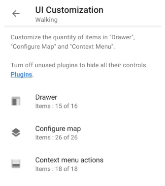
UI Customization
Customize the quantity of items in "Drawer", "Configure map" and "Context menu actions".
Turn off unused plugins for hide all their controls.
Menu → Configure profile → UI Customization
Under each menu there is the info about items quantity / active items.
Drawer
In this part of the menu you reorder or hide items from the Drawer.
| Actions: Note |
|---|
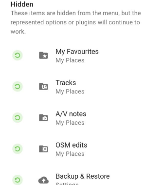
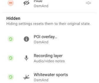
| "Minus": These items are hidden from the menu, but the represented options or plugins will continue to work. |
| "Moving": These items are moved to other positions in the menu. |
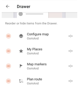 |
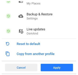
| "Reset": These items are reset from the "Hidden" part of the menu to the visible. |
 |
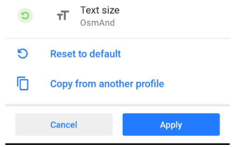
| "Reset to default": resetting the "Drawer" menu to default. |
| "Copy from another profile": coping the "Drawer" menu from another profile. |
 |
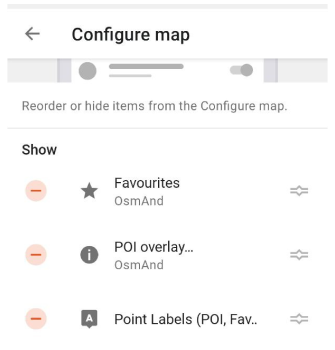
Configure map
In this part of the menu you reorder or hide items from the Configure map menu.
| Actions: Note |
|---|
| "Minus": These items are hidden from the menu, but the represented options or plugins will continue to work. |
| "Moving": These items are moved to other positions in the menu. |
 |
| "Reset": These items are reset from the "Hidden" part of the menu to the visible. |
 |
| "Reset to default": resetting the "Configure map" menu to default. |
| "Copy from another profile": coping the "Configure map" menu from another profile. |
 |
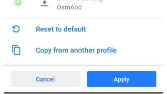
Context menu actions
In this part of the menu you reorder or hide items from the Context menu actions menu.
| Actions: Note |
|---|
| "Minus": These items are hidden from the menu, but the represented options or plugins will continue to work. |
| "Moving": These items are moved to other positions in the menu. |
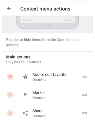 |
| "Reset": These items are reset from the "Hidden" part of the menu to the visible. |
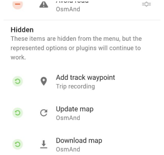 |
| "Reset to default": resetting the "Context menu actions" menu to default. |
| "Copy from another profile": coping the "Context menu actions" menu from another profile. |
 |
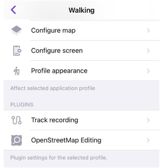
Plugin settings
:::cation To access the plugin's settings, you must first enable the plugin in the Plugin section of the Main menu. :::
Plugins unlock additional functions of the application, they can be either paid or free. Not all the plugins have their own settings. You can configure plugins for each profile separately.
- Android
- iOS
Menu → Settings → Configure profile → Plugin settings
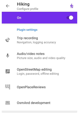
Menu → Settings → App profiles → Plugins
Trip recording
This menu opens the trip recording settings for the selected profile. Where you can choose any parameters for recording your trip.
- Android
- iOS
Menu → Settings → Configure profile → Plugin settings → Trip recording
Menu → Settings → App profiles → Plugins → Track recording
Audio / Video notes
This menu opens audio-video plugin settings for the selected profile. Where you can choose any parameters for your needed.
Menu → Settings → Configure profile → Plugin settings → Audio/video notes
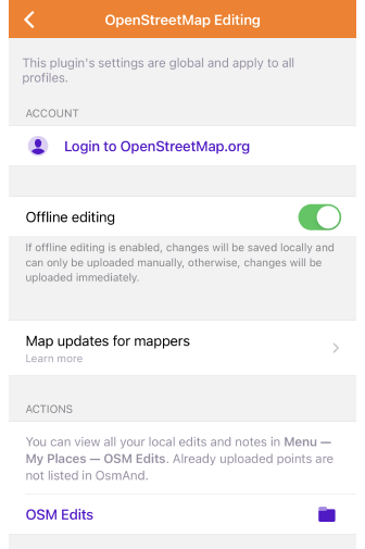
OpenStreetMap editing
This menu opens the OpenStreetMap editing plugin settings for the selected profile. Where you can input your data for starting OSM edit.
- Android
- iOS
Menu → Settings → Configure profile → Plugin settings → OpenStreetMap editing
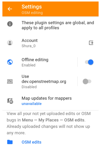
Menu → Settings → App profiles → Plugins → OpenStreetMap editing
Accesibility
Go to: Menu → Settings → Configure profile → Plugin settings → Accessibility
This menu opens Accessibility plugin settings for the selected profile. Where you can choose any parameters for your needed.
OsmAnd development
Go to: Menu → Settings → Configure profile → Plugin settings → Development
This menu opens Development plugin settings. Here you can configure the OsmAnd app for testing or try new features. These settings are intended for developers, and are not required for normal use of the application.
Changing the settings of the OsmAnd development plugin affects all profiles.
Wikipedia
This feature is currently not available for the Android version of the OsmAnd app.
Go to: Menu → Settings → App profiles → Plugins → Wikipedia
This menu opens Wikipedia plugin settings. You can choose in which language the articles will be shown to you, and decide whether to download images from Wikipedia or not.
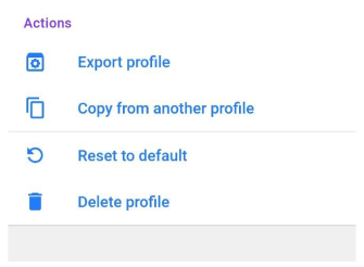
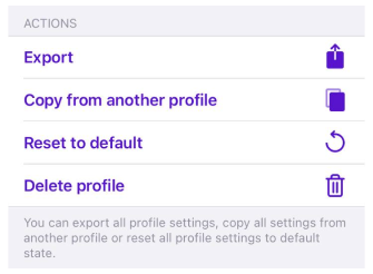
Actions
Actions with chosen profile:
- Export profile.
- Copy from another profile.
- Reset to default.
- Delete profile.
- Android
- iOS