Nautical Map View
Overview
The Nautical Map View plugin is a paid feature.
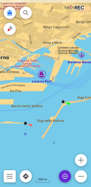
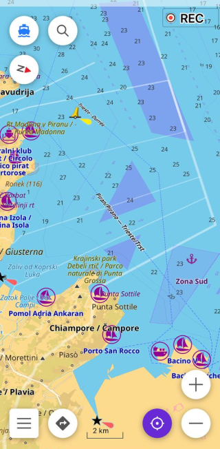
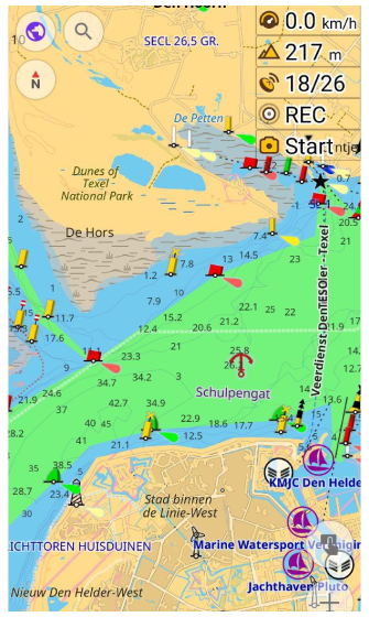
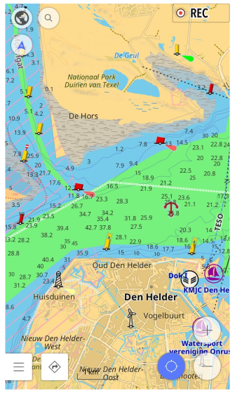
Nautical Map View is a detailed graphic representation of oceans, seas, coastal areas, and rivers that helps you navigate the water and know popular routes, obstacles in your waterway, nearest harbors, anchorages, and other important landmarks.
A nautical map is a highly detailed topographical map to help skippers navigate a vessel on a selected course on the water. It is similar to a road map for those traveling by car. Often called a 'Chart' for historical reasons, it is a detailed graphic representation of the oceans, seas, coastal areas, and rivers.
Nautical maps are important for professional sailors and amateurs who rent a boat to cruise the city's canals. The maps provide them with various information such as sailing routes, navigation lights, danger zones, zones where it is allowed or prohibited to sail or dock, etc.
- Android
- iOS
Why the Nautical Theme Matters
All professional sailors are required to have official nautical maps on their ships. These maps are published by authorized agencies and are quite expensive. The agencies invest heavily in keeping the maps up to date. They issue regular updates to the maps, but because it takes time to verify the information and process the updates, nautical maps are never completely up to date.
Based on OpenSeaMap data, OsmAnd Nautical maps are created by people who use them. Each map user can contribute to the map by adding information they find important and useful for themselves, thereby making the map more detailed and accurate, ideal for orienteering or route planning.
Required Setup Parameters
The following setup makes the Nautical map show up on the screen:
- Purchase and Enable Nautical map view plugin.
- Download the Nautical maps.
- Set the Nautical map style for the required profile.
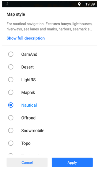
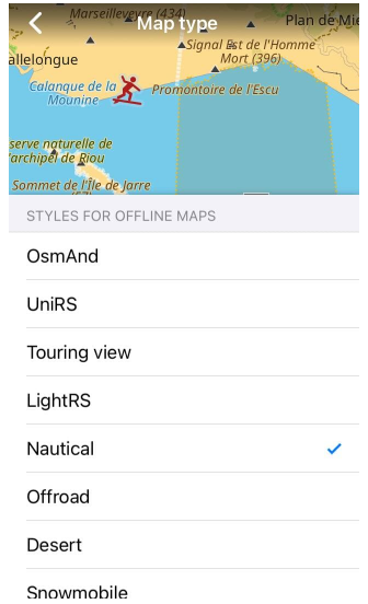
Set Nautical Map Style
- Android
- iOS
Go to: Menu → Configure map → Map rendering → Map style → Nautical
Go to: Menu → Configure map → Map type → Styles for offline maps
Use the Map legend for any reference to what is shown on the nautical map. It explains the symbolic elements on a nautical map and serves as a reference to help you navigate when in doubt. By setting the Nautical map style, you can get the best view of the downloaded and displayed nautical data.
To change the current map style to Nautical, you need to make the following settings:
- Select the required profile.
- Open Configure map.
- Scroll down to Map style, open it, and check the Nautical.
Download Nautical Maps
- Android
- iOS
Go to: Menu → Maps & Resources → Nautical maps
Go to: Menu → Maps & Resources → Nautical maps
For optimal presentation, maps can be adapted to current needs: marks and symbols can be added with depth points and, as needed, contours. On the other hand, standard maps with information about inland, onshore, and nearshore waters information for a particular region can be a good complement to the information about waterways on a Nautical map.
When you download a nautical map, more details related to Boat navigation appear on the map. Some types of Nautical maps contain details such as:
-
Nautical marks and symbols.
Marks and symbols contain all nautical navigational marks for both inland and coastal navigation. Knowing these marks will help you predict the location of rocks, obstructions, anchorages, buoys, currents, deep and shallow water, and sides of the channel, regardless of the direction, etc. Marks and symbols are downloaded once for the entire world. -
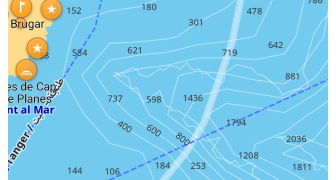
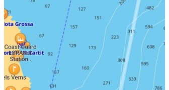
Depth points.
Nautical data from the depth point packages are represented by numbers displayed on the water that indicate the shallowest depth at a particular location. Depth points are available for each hemisphere and some regions. -
Depth contours.
Depth contour packages allow you to define areas of equal depth. They are intended to visualize changes in relief beneath the water's surface. Depth contours can be downloaded for certain areas and then turned off if you do not need them.
All depth numbers on the Nautical Maps are indicated in meters.
Disable Nautical Map Style
To remove Nautical and display one of OsmAnd's conventional maps, do any of the following:
- Disable the Nautical plugin.
- Change the map style to anything else than Nautical.
Disabling the Nautical plugin does not remove loaded nautical data, so even if you change the rendering method from nautical to any other method when nautical data is downloaded, it remains visible on the map.
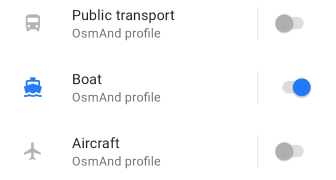
Nautical Profile
- Android
- iOS
Go to: Menu → Settings → App profiles
Go to: Menu → Settings → [object Object]
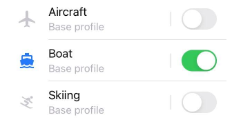
Nautical map can be included in any profile. However, it is most valuable in the Boat profile and especially in Boat navigation.
Nautical Map Style
The Nautical plugin in OsmAnd extends the vector layer map styles with the Nautical map style. It allows you to display map data according to Nautical map rules, for example: yellow areas for land and shoals, light blue areas for shallow waters, etc. For more information, see Map legend.
Seabed Detail
- Android
- iOS
Go to: Menu → Configure map → Other map attributes → Seabed detail
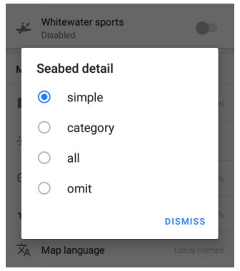
Go to: Menu → Configure map → Map style → Details → Seabed detail
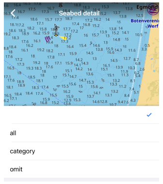
Seabed data contains information about vegetation and general surface material such as rocky rocks, shells, gravel, coral, silt, etc. Due to the international classification of seafloor data, there are options for displaying such details on a map: simple, category, all or omit. Use the Seabed area map legend for more information.
- Simple (for Android version)- shows the seamark symbols in accordance with INT-1 Ref, indicating the nature of the seabed surface.
- Category - in addition to the seamark symbol, also shows the relevant seamark tag, indicating the natural material, or the seaweed and seagrass category.
- All - in addition to the seamark symbol, tag, or category, also shows qualifications such as fine, sticky, coarse, etc. For seagrass and seaweed, shows data marked with the taxon and genus tags.
- Omit - does not show details of the seafloor.
For more details on the classification of the surface details and the rendering options, refer to OSM's seamark wiki.
Light Detail
Android Go to: Menu → Configure map → Map style Nautical → Other map attributes → Light detail
IOS Go to: Menu → Configure map → Map type Nautical → Details → Light detail
This option вisplays the level of information for navigational lights. You can choose how detailed the light characteristics appear near each lighthouse or beacon.
- Simple – shows the default seamark name and light characteristic .
- Sectors – displays full sector arcs and details for all visible light sectors.
- Sector 1–5 – shows details for a specific sector number only.
- Small – uses a compact label format for light characteristics.
- Name only – shows only the name of the seamark without light data.
- Omit – hides all light information.
Marine Map Style
- Android
- iOS
Go to: Menu → Configure map → Map style → Marine
Go to: Menu → Configure map → Map type → Marine
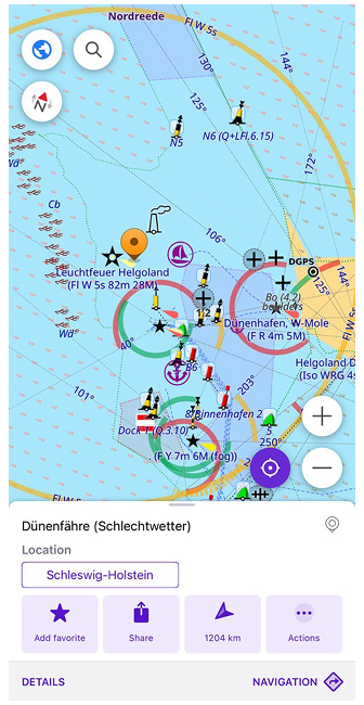
This style adds visual elements for maritime navigation, including navigation lights with INT-1 light characteristics, which describe the type, color, and rhythm of a light signal (for example, whether it flashes, its color, and the interval between flashes), and colored sector lights that indicate the direction and color of the light visible from sea.
In the Marine style, light sectors are displayed around lighthouses and beacons: white (shown in yellow on the map) indicates the safe direction for navigation, red marks dangerous or restricted areas, and green shows auxiliary or lateral directions.
To display this information, the Nautical plugin must be enabled, and the World Seamarks map (or World_seamarks_2.obf) must be downloaded. Information is not for official navigation use.
Map Attributes
- Android
- iOS
Go to: Menu → Configure map → Map style Marine → Other map attributes
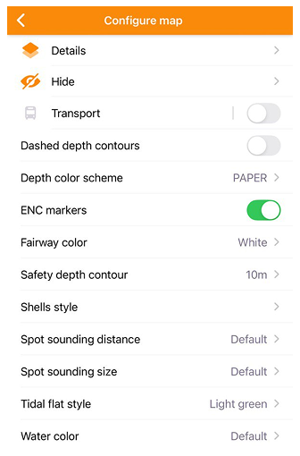
Go to: Menu → Configure map → Map type Marine → Details → Light detail/Seabed detail
Go to: Menu → Configure map → Map type Marine → Choose other options
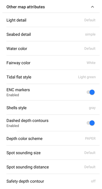
After enabling the Marine map style, you can fine-tune additional visual elements. These options allow you to control how navigation aids, depth contours, seabed details, and colors appear on the map.
- Light detail. Defines how seamark light information is displayed. Options: *Default (full name with light characteristics), Small (compact format), Name only (light name only), or Omit (hide labels).
- Seabed detail. Controls the level of textual information about the seabed. Options: Simple (basic info), Category (surface type), All (full data), or Omit (no text).
- Water color. Sets the base color for water areas. Options: Default, Blue, White, or Gray — useful for adjusting visibility and contrast under different lighting modes.
- Fairway color. Changes the color of navigational fairways and channels. Options: White, Whiter, Gray, Green, or Yellow to improve readability depending on chart background.
- Tidal flat style. Adjusts the color and texture used for tidal flats. Options: Light green, Dark green, Wetland, or Tidal — each highlights shallow intertidal zones differently.
- ENC markers. Toggle On/Off. When enabled, shows Electronic Navigational Chart (ENC) markers such as buoys, beacons, and other navigation aids.
- Shells style. Defines how shells or bottom surface features appear on the seabed. Options: Gray, Rocks, Stones, or Red, depending on the visual style preferred.
- Dashed depth contours. Toggle On/Off. When enabled, displays depth contour lines as dashed, enhancing readability in dense areas.
- Depth color scheme. Selects the color scheme for depth zones. Options: PAPER (traditional paper chart colors) or ECDIS (standard electronic navigation system palette).
- Spot sounding size. Sets the font size for spot sounding numbers (depth values). Options: Default, 10, 12, 14, or 16 — larger values improve visibility on high-resolution screens.
- Spot sounding distance. Controls how frequently depth soundings appear on the map. Options: Default, 0, 5, 10, 15, 30, 60, or 120, determining the spacing between displayed depth points.
- Safety depth contour. Highlights the contour line marking the safety depth threshold. Options: Off, 0 m, 1 m, 2 m, 3 m, 4 m, 5 m, or 10 m. Useful for distinguishing safe navigation areas from shallow zones.
Additional Nautical Data
Depth Points
- Android
- iOS
Depth point packages are available for Europe, the Northern Hemisphere, and the Southern Hemisphere and are informational. Depth points indicate changes in topography below the water's surface, indicating the shallowest depth. This is necessary for Boat navigation. After downloading, you need to turn on Depth contours to display it on the map.
Depth Contours
- Android
- iOS
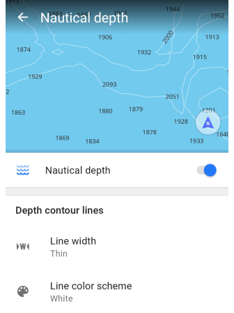
Go to: Menu → Configure map → Show → Nautical depth
Go to: Menu → Configure map → [object Object] → Nautical depth
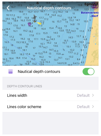
When a Nautical map is displayed on the screen, you can adjust what you see:
- Show or hide the Depth contours.
- Setting the detail level of the seafloor information: Line width and Line color scheme.
You can help the OsmAnd app increase the Depth contours database by adding your information using OpenSeaMap