OsmAnd 4.3 (iOS)

Hi there!
We are glad to announce the release of the iOS app version.
Development doesn't stand still, and now the new improved version is available for installation on your devices!

- New purchase plans: "OsmAnd Pro" and "Maps+":
- Cloud backup and Offline Weather for OsmAnd Pro;
- New "Purchase" screen.
- New colors for Tracks and route line.
- Updates for Favorites.
- Updates for CarPlay.
- Added smooth animation.
- OsmAnd Live for OSMers.
- OsmAnd data for Files app.
- Added support of GPX tags.
- Added mode for the Compass button.
- Added FPS widget.
- Added IMBA trails.
- On/off downloaded maps layer.
- More:
- Fixed an issue with UTM Coordinates format.
- Fixed an issue with intermediate points in navigation.
- Added Canadian road signs for Speed limit and Railway crossing.
New purchase plans
In this release, we added new subscription plans named "OsmAnd Pro" and "OsmAnd Maps+". OsmAnd Pro is a new subscription plan with access to all features, and "Maps+" - with unlimited map downloads and access to paid plugins.
OsmAnd Pro is a cross-platform subscription (you can use it for both Android and iOS versions of OsmAnd after registration on our servers).
Read more about iOS purchases here.
New paid features
These features are available for OsmAnd Pro subscribes:
- OsmAnd Cloud (Backup & Restore)
- Weather forecast
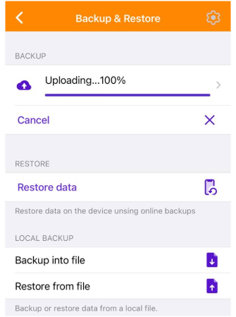
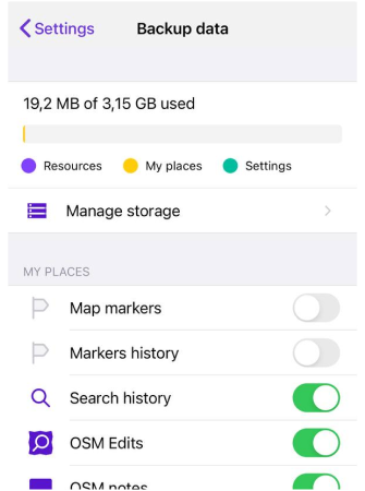
Cloud backup
Menu → Settings → Backup & Restore
Read more info here.
 |  |
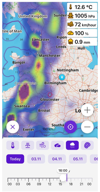
Weather forecast
Hourly forecast for the current day and 7 days ahead on the map.
The Weather plugin: Menu → Plugins → Weather
Download the weather forecast in the Maps & Resources menu for offline use: Menu → Maps & Resources → Map Region → Weather forecast.
Weather widgets: Temperature, Pressure, Wind, Cloud, Precipitation. Shows these parameters for the central point on a device screen.
Weather screen menu: Menu → Weather
Weather map layers: Menu → Configure map → Weather
 |
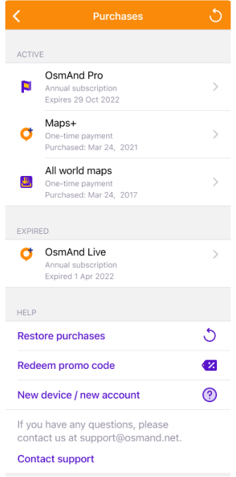
New Purchases screen
Menu → Settings → Purchases
- "Active" - a list of users' active purchases.
- "Expired" - a list of inactive purchases.
- "Learn more" button - opens a menu with puchases screen.
- "Help" menu:
- "Restore purchases" button - allows to restore user purchases.
- "Redeem promo code" button - opens iOS instruction.
- "New device/new account" button - opens OsmAnd docs.
- "Contact support" - allows to send email to OsmAnd support team.
 |
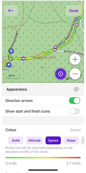
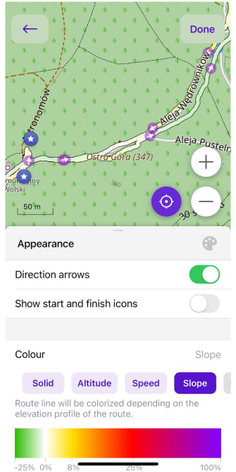
New colors for tracks and route line
Tracks and route line can now be colored by Altitude, Speed, Slope, Surface, Smoothness.
Solid, Altitude, Speed - for free use.
Slope, Surface, Smoothness - for OsmAnd Pro.
 |  |
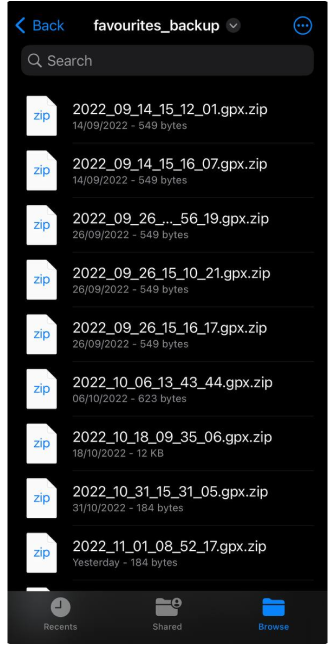
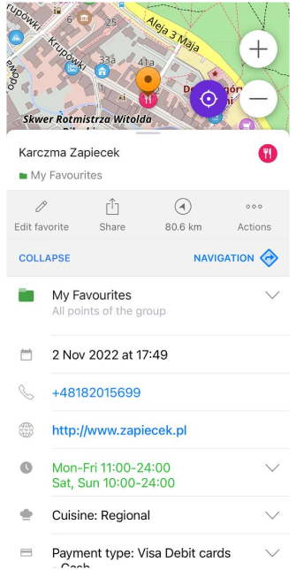
New updates for Favorites
Local backup
Added local backups generation after each change, backups accessible from the Files app.
A backup file is created each time you save or edit a Favorite.
Files → On my iPhone → OsmAnd Maps → favourites_backup
 |
POI data
POI saved to favorites will store and show all POI data even without an offline map.
 |  |
CarPlay improvements
Added additional fixes and features for CarPlay mode:
- added road lanes to the CarPlay screen;
- 2.5D view;
- fixed a bug with Bluetooth voice connection.
CarPlay is a Paid function.
Smooth animation
Routing animation (icon movement during navigation) works smoothly now.
OsmAnd Live for OSMers
Free using OsmAnd live feature for active OSMers.
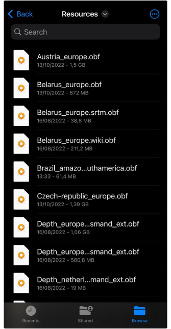
Files app updates
Now, you can see OsmAnd maps files in Files app:
Files → On my iPhone → OsmAnd Maps → Resources
 |
New updates for GPX files
Support of custom extensions, link, cmt, desc tags.
- Favorites: show content of
<cmt>tag similar to waypoints:
<wpt lat="30.297375" lon="-87.4320327">
<name>Caf� Beignet</name>
<cmt>Open 6:30 am to 12:00 pm. Closed Sun & Wed</cmt>
</wpt>
- Phone numbers for the Waypoint attributes:
<wpt lat="52" lon="5">
<extension>
<phone>My phone number</phone>
<website>https://test.website</website>
<comment>Comment</comment>
<extension>
</wpt>
- Tags for description: name, desc, cmt, link.
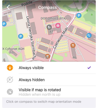
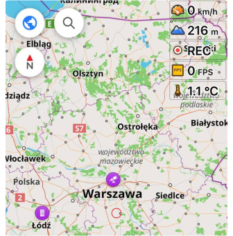
Compass modification
Changed settings for Compass.
Menu → Configure screen → Compass:
- Always wisible.
- Always hidden.
- Visible if map is rotated (hidden when north is up).
 |
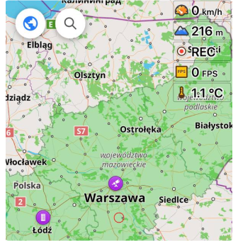
FPS widget
FPS widget is the part of OsmAnd development plugin.
This is a Development plugin widget to investigate the speed of displaying and updating the map and map elements. It displays:
Map refresh FPS - update points and routes on the map (smaller number).
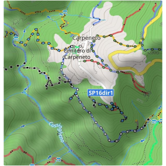
MTB IMBA trails
OsmAnd now renders the MTB IMBA trials on the map.
You need to switch on Show MTB IMBA trails in: Menu → Configure map → Routes → Mountain bike → MTB Scale/IMBA.
Here is an example of the MTB IMBA icons for the trails and the legend for those icons:
 |  |
Downloaded maps layer
Added the ability to show or hide the layer of downloaded maps:
Menu → Configure map → Show on map → Show borders of downloaded maps
 |  |
More
- Fixed an issue with UTM Coordinates format.
- Fixed an issue with intermediate points in navigation.
- Added Canadian road signs for Speed limit and Railway crossing.
Follow OsmAnd on Facebook, TikTok, X (Twitter), Reddit, and Instagram!
Join us at our groups of Telegram (OsmAnd News channel), (EN), (IT), (FR), (DE), (UA), (ES), (BR-PT), (PL), (AR), (TR).
